
August 6, 2015 we joined our dear friends Jon and Heather Togstad for a hike north on the Pacific Crest Trail in Central Oregon. We joined them just over half way on their 450 mile hike through Oregon. We are hoping we can keep up with these two! The cabins at Elk Lake Resort, where we met them are tiny but very cute and cozy.

At the lakeside diner we had breakfast burritos while dodging the pine cones being dropped by the overly industrious chipmunks 100 feet above us in the fir trees.
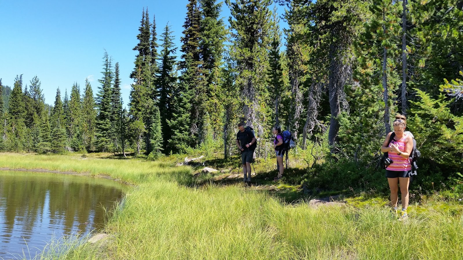
At six miles we stopped for a break at a small lake. Realizing it was not Sisters Mirror Lake, but a smaller unnamed lake we immediately christened it Little Bird lake after a small white bird in residence there.

Continuing on we made Wickiup Plains and the views of South Sister were very impressive. We would be treated to an up close and personal view the rest of the evening. The Three Sisters were originally named Faith (North), Hope (Middle) and Charity (South). There was a Methodist mission in Salem that is generally accredited for the naming. They have since become known as Three Sisters.

South Sister or 'Charity' became our first big landmark and it would take all day to get past her. South Sister is the youngest of the three and has Oregon's highest lake in her crater at the top, called Teardrop Pool. It is a relatively easy climb to the summit at this time of year requiring no technical ability if approached from the south.

We camped just past Separation Creek near a pond on our first night. Most creeks this year are dry already. Oregon snowpack this last winter was 11 percent of normal. With this in mind the small lakes are the most reliable water source. Water weighs 8 pounds a gallon so camping near reliable water is very practical. We hiked 15 + miles this day and our campsite was beautiful in the morning light.

Continuing north on day 2 we passed above beautiful Linton Meadows and into the Obsidian limited access area. This place is littered with innumerable shards of sharp obsidian lying about. Boulders laced with obsidian covered the hillsides and this 4 foot high boulder was beside the trail. This area must have been a wealth deposit for native people for surely this sharp instrument gave them immediate efficiency in tools and weaponry.
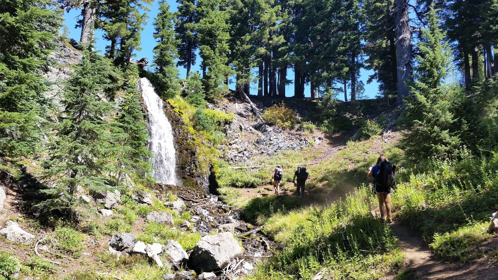
Obsidian Falls is a surprise and welcome oasis in a extremely dry year. Above it we find streams that bubble from the earth in several spots of the meadow within 100 yards of the falls. It is a great place for lunch and a rest.

The headwaters of Obsidian Creek are all within this small meadow.

Cleo got her first run with her new doggy hiking boots in this section. She looks like a Clydesdale at first and rolls in bushes to try and kick them off. She would be in these boots for much of the next 20 miles.

Just beyond the Obsidian area the trail turns east and ascends through the Opie Dilldock Pass. This pass was named by two forest service men who had trouble finding a practical way through the lava. They named it in honor of a comic strip character of the early 1900s named Opie Dilldock who always found some way out of impossible situations. This pass was a brutal climb in the hot afternoon and continued to be lava strewn for the next 5 miles.

In this stretch we met a couple of southbound through hikers who informed us of some great trail magic at Lava Camp, 1/2 mile off of the PCT. We had intended to camp 3 miles earlier but the promise of Bratwursts, chili and chips with cold pop and beer drove us on. In the interest of ensuring that the reader understands one of the underlying themes of this hike it is prudent to mention a couple of things that are very particular to the subculture that is long trail hiking, not just on the PCT but other long trails as well like the Appellation Trail or the Continental Divide Trail.
- Through Hikers are hikers that start at one end of a trail and attempt the whole thing in one shot. They generally smell pretty ripe, have filthy clothing and are very friendly.
- Section Hikers are likely to smell, be dirty, be nice etc. but they are doing some section of the trail. In our case Jon and Heather were doing the entire state of Oregon as a section. Jennifer and I were doing just a portion of Oregon.
- Trail Angels are people who unselfishly put out 'Trail Magic' to support the hikers, often at places where it could be very critical like jugs of water in a dry stretch. Other times it is a ride to town for supplies or perhaps a cold soda or a hot meal of something other than rehydrated food.


We were especially thankful for the water so we did not have to filter it from the lake. Our next 16 miles were waterless, much of it the lava flows south of Mt Washington and burnt forests north of Mt Washington. At 1 liter per person (and dog) per 4.5 miles we carried 10 liters out of camp or 20 pounds between Jennifer and I. Jon and Heather carried much the same.

Looking North we had a 5 mile shadeless mass of Lava to cross bringing us next to Belknap Crater. Following that was an interesting mix of lava and burnt forests for three miles and another 3 miles of dusty burnt forests on the southern flanks of Mt Washington.

Much of the next couple of days of hiking was very exposed due to recent wildfires in the area. In 2003 the B & B complex fire burned 90,000 + acres between Mt Jefferson and Mt Washington over 34 days. In 2006 The Lake George fire burned 21,000 + acres over 38 days on the east side of Mt Washington. In 2011, when Jennifer and I were hiking the Three Sisters we actually saw the Shadow Lake fire in its infancy to the North. It would go on to burn about 10,000 acres north of Mt Washington over about 30 days. This fire burned right up to the edge of Big Lake Youth camp and it was very obvious as we hiked into the camp where the stand had been made to save the camp.

At the Big Lake Youth Camp they are very supportive of PCT hikers. They have set aside one of their many dwellings for PCT hikers and we saw several familiar faces. In there you can lounge on couches, charge your phone or rummage through the 'hiker boxes' These are boxes of stuff hikers discard because they don't need or want so others may make use of it. We got two small cans of Vienna sausages for Cleo as were low on dog food. In addition you can get a shower here. We had been on the trail only three days and this was still very welcome.
Skipping dinner and the offer of a campsite in a designated area for PCT hikers we headed north and road walked a mile to the PCT. At that junction a young guy came running over across the dusty road and asked if we were PCT hikers. He was excited we were and was there with 'trail magic' in the form of good beer and oranges. We chatted with him and his friends for awhile and learned he had hiked the entire PCT in 2013 and got within 7 miles of the Canadian border when a group of 15 or more hikers was turned back as a result of the October 1 2013 government shutdown prescribed for America by our wonderful legislators.
We camped that third night in a meadow at the end of an unnamed lake just south of Santiam Pass. At Santiam Pass we met John and Heathers son, Jake for our resupply. Jake is super likable and brought us Pizza, cold drinks and gallons of water. Also at Santiam Pass were Legend, Half Slow and 4 other through hikers. Legend runs support for Half Slow and he was delivering 'trail magic' by way of a ride to Portland for the four through hikers. They were from around the US and took notes on what to do besides VooDoo Donuts and the Hawthorne district... We headed out north and said our goodbyes. The next couple of hours we hiked up exposed burned ridges.


As we rounded the northeast side go Three Fingered Jack the weather began to change. From the ridge the view is magnificent with all of the colors of the rainbow seemingly represented in the scene below and in front of us. the green valley meadow and the red rocks of the mountain competed in brilliance for our attention.
After descending off of the north side of Three Fingered Jack, we hiked down from Minto Pass to Minto Lake for our fourth nights camp. The lakeside camps were filled but we were fortunate to find this gem a little higher up.

Minto Lake is surrounded by the burns of the 2003 B & B fire. In the morning light it is golden and quiet below the spires of Three Fingered Jack.


After leaving camp we climbed back up to Minto Pass. At Rockpile Lake we swam, sunned, ate and got rained before continuing on. With the weather chasing us with thunder we continued on or near the ridges.

With Three Fingered Jack behind us we hiked in front of an oncoming rain and thundershower. The hail that fell was the size of peanut M&Ms

Our connections with Mt Jefferson (the native american name is Seekseekqua) became more and more intimate as we approached this magnificent mountain from the south. Like many of the Cascade Stratovolcanoes that dot the Cascades it rises strong and vibrant above the landscape. Unlike the others this mountain is remote and relatively hard to reach. There are no 'drive up' views up close and personal. Perhaps more than any other big mountain experience this was much more intimate for this very fact. My exposure to this mountain had been from Highway 26, nearly 20 miles away, a snow covered bump on the horizon.

A side trail proves irresistible and provides a tantalizing glance back south for the girls.
The likelihood that there is a cliff prevents me from getting much closer!

Heather and Jennifer pause near the Togstad 300 mile mark to take in the Red Elderberry in full fruit. While this appears to be a pose, this is a actually a normal break stance for these two beauties....lick your lips...chin up...

Wow! These two indomitable spirits are inspiring to say the least. This is the three hundred mile marker for the Togstads on this hike. At this point the Colby's are at 66 miles. IF I ever hike three hundred miles you will see my limp body lying next to my 300 mile marker with a faint effort at a smile! Very inspiring and we would be blessed with these smiles throughout the duration of our hike with them.

This was as beautiful as it looks. Jon and Heather are reflected across the shores in Shale Lake. Mt Jefferson hovers over their shoulders and is played out at their feet in it's reflection.
We set up our fifth nights camp just beyond Shale Lake restricted zone. Restricted zones for popular and sensitive hiking destinations are becoming increasingly popular among resource managers. In this case we found a campsite just north of the zone but before the long steep grade down to Milk Creek.
The descent in the morning provided a view far below of popular Pamelia Lake fed by Hunts Creek. These valleys are the quintessential high mountain valleys of lush green meadows dissected by meandering streams. At Milk Creek we filtered water and had lunch. What followed was a long climb to Russell Creek. This crossing was mid-day, not the worst time as glacier fed streams get dramatically more robust as evening progresses. However, Russell Creek was roaring when we arrived and a spot 100 yards upstream seemed our best chance at success. The crossing went well due in no small part to Jon's tall frame and large wingspan. He balanced mid-stream and I passed the dog to him and he passed her swiftly onto a rock. He helped us all across without incident.


Following a half mile climb we found ourselves winding our way up the truly milky white Whitewater Creek through the splendid Jefferson Park. It's meadows were lush but the many marshes and ponds that feed, nourish and house the flora and fauna were all but dry.

We stopped at Russell Lake where we packed on water for a long climb over Park Pass to the north.

The climb provided unlimited perspectives to turn and marvel at the views south to Mt Jefferson and the powerful glaciers dominating it's northern faces.

Cleo has time to smell the flowers on the uphill climbs...:)

We could hear a new weather from pushing North from beyond the mountain.

Soon we could see the sheets of rain and even the lightning so close it made some of us jump! We were fortunate in that the weather passed right next to us before turning just north of to the east.

At Parks Pass we had our most majestic views yet. The ridge provided views of what lie before us to us to the north as well.

We were surprised and delighted to see an American flag planted among the rocks on the trail down towards Breitenbush.

The backside was steep and rocky and we camped our sixth night in a small meadow beside the trail.
In the morning we hiked down to Ollie Lake. Here we once again saw Legend. He had returned to Santiam Pass and agreed to carry the packs to two guys who wanted to do an all nighter. They took a few bars, headlamps and a waterbottle /filter and took off for a 23 hour - 44 mile marathon to Ollie Lake or what had taken us three days- so crazy. Legend provided yet more trail magic in the form of chilli dogs, a through hiker provided a bag of huckleberries she had picked and Jennifer passed around a bag of Cool Ranch Doritos and we all hung out on the porch of the store for a couple of hours. We resupplied and and eventually hiked on to Jude Lake for our seventh night. This night would be our last with Jon and Heather. They had miles to go and timelines to keep and it was becoming desperately clear that I would not be able to keep up.

The following morning we all loaded up again with water to make it the 15.6 miles to Warm Springs River. Once again this meant 9 liters or 10 pounds each to our pack. We parted ways with Jon and Heather early in the morning. Their pace was faster but it was hard for Cleo to not run ahead to try and find her sheep. All day she could smell them but not see them and she was held on heel most of the day to help her conserve her energy. We spent this entire day on the Warm Spring Indian Reservation in beautiful forests. We took lunch at Lemiti Creek That evening we arrived at Warm Spring River and found it's few campsites taken. We proceed a quarter of a mile and that eighth night Jennifer, Cleo and I camped near a spring.

The next day we awoke with our spirits high. We knew by now that we would be cutting our hike short due to a plethora of ongoing injuries I was experiencing, resulting in excruciating pain at both achilles and dating back to the first day of our hike in my new boots with just 10 miles on them. At the first sign of cell phone coverage Jennifer texted for 'an extraction' by Amy Lou who graciously agreed to drive out to the middle of no where and hope to bump into us. We hiked about ten miles that morning all the while Cleo could smell Jon and Heather on the trail. When we emerged from the forest on Road 42, the extraction point, we found Legend. He was set up and was serving trail magic in the form of pancakes and coffee. Our friends, Jon and Heather and several hikers we had met including Half Slow and Smokey had left just an hour and a half before having finished their share of pancakes. We ate pancakes and agreed to assist Legend by driving one of his two rigs to Frog Lake, his next destination, Amy pulled up surprised to see us. She had chocolate and Coke!

In the end we were happy to be headed home to the comforts of that included me being off of my feet for awhile. Suffice it to say we were sad to be leaving our adventure but will add Timothy Lake to Cascade Locks to our list of future hikes.