Monday, May 28, 2012

Siouxon Creek Trail


Siouxon Creek Trail

A hike through a forest floor with the rotting remnants of old growth snags and deadfall all dressed up in moss.

Chinook Falls on Chinook Creek, in Southwest Washington.

This out and back hike is a great stroll up Siouxon Creek just west of Trapper Creek Wilderness in Southwest Washington. 


This bridge over West Creek is near the beginning of the hike through a lush second growth forest. Just beyond it were the first of several great campsites along the trail.


The trail is used  extensively by mountain bikers who enjoy the relatively gentle rise and fall of the trail as you ascend the valley. Cleo loves the puddles laced with their tracks.
Oregon Grape in bloom


Horseshoe Creek Falls  


The trail cuts deep into Horseshoe Creek crossing on a small bridge above a series of beautiful waterfalls. Just beyond them is a bench below with several goos campsites and views of these falls.


Falls on Siouxon Creek


 This Douglas fir has used an old snag for support as well as nourishment.


Wild Bleeding Heart or Dicentra formosa.


The trail follow the Siouxon Creek more or less. The water is crystal clear and makes you think this would be a great summer swim spot, albeit cold.


We were surprised to find snow. We quickly realized it was hail from the thunderstorms from the day before that had hit all over Clark County and Portland. We saw big Skunk Cabbage leaves that looked like they had been shot with a shotgun. We did not know it but there would be more thunderstorms later this day.
Hail from the day before.


What a great place to take lunch. The trail up Chinook Creek is worth the small trek. We watched five fathers and their boys ford her while eating our lunch.


This is just an amazing place full of dead rotting trees feeding the forest.


A side trail led up to a bit of a cave that looked cool from a distance but was actually more of a big dark overhang. Like us, enough people were interested to eventually result in a trail.

This out and back hike came in at 9.6 miles on the GPS. The lush healthy forest and the beautiful creeks with waterfalls makes it a great and relatively easy hike.


Monday, May 21, 2012

PCT near 3 Corner Rock south to Table Mountain

We began this hike on the Pacific Crest Trail where it crosses a small forest road 2090 about 30 miles from Washougal, Washington.


The gentle grade for the first 1.5 miles provided a few glimpses of the surrounding vally to the East and eventually the north as well. Spring is just getting around to business up here and we found ourselves among plenty of Wind Flower's both white and purple.We also found long deep patches of snow but the trail was easy enough to follow.
 After passing a great rock outcropping overlooking the Rock Creek Valley with Sedum Ridge beyond and Mt Adams in the background.


Mt Hood 

Mt Adams


 At one point we came out into a Clearing where we were able to stand in one spot and see Mt St Helens and Mt Ranier to the North, Mt Adams to the East and Mt Hood to the South.


Mt St Helens on the left, Mt Ranier on the right.


After crossing a couple of logging access roads the trail gently climbs up to a saddle overlooking Greenleaf Basin to the East and Hamilton Creek basin to the West.


With Table Mountain as our goal we continued on a gradual downhill until the trail curved around the hill towards the West. Here we found a small barely used trail down through the brush towards Table Mountain.


Leaving the PCT, we made our way to the powerlines and continued on an old log road south for several hundred yards until it became a small brushy trail following the ridge up the back side of our destination. Mainly we saw Trillium in the forests but the meadows are beginning to show Indian Paint Brush and some beautiful Red Currant bushes.


The reward was a stunning view East and West up the Columbia River gorge. Here we took lunch and watched two Bald Eagles fly together over the Greenleaf Basin, gliding from far below us slowly until they were far above us.


Our Return would bring us back the way we came but the views are different because I always forget to look back on the way in! This was a 13 mile hike and well worth the effort.


Tuesday, May 15, 2012


Cape Perpetua

This 2700 acre park on the Oregon Coast is a great place for some day hiking. It is located 3 miles south of Yachats Oregon. There are ten trails to choose from that range up to 10 miles. We chose the ten mile hike. 


We parked along road 55 just off highway 101. A half mile hike south took us through the campground and up to the visitors center. From there we chose the Cooks Ridge Trail. We hiked up through forests of Spruce, Hemlock and Fir to a junction with Cummins Creek Trail.


 Along the way we saw this monster of a stump. Ancient and weathered, we marveled at its immense size and beauty.


Western Trillium finds a ray of sun to brighten up the forest floor beneath old growth forests. 


The Oregon Oxalis is everywhere  and like the Western Trillium brightens the forest floor in Spring.


This opening in the forest sits above a large open meadow on the south side of a hill overlooking Cummins Creek and the Pacific Ocean


English Daisy


 The Yellow Monkey Flower


Woodland Flox and English Daisy?


At the bottom of Cummins Creek Trail we took the Oregon Coast Trail North to the visitors center.


This trail travels the entire length of Oregon. Most of it is on the beach made possible by the Oregon Beach Bill of 1967 making public property of the beaches. Of the 382 miles, 150 miles are on pavement. This one mile section follows the original wagon trail that predated Highway 101.


Cape Perpetua and the Pacific Ocean and...well... me.


Smiths Fairybell lines the path from the visitors center back to our car


Spring 2012 Hiking


Hardy Ridge, Washington
 This spring we hiked up Hardy Ridge in the Beacon Rock State Park in Washington State. This ridge is directly west of Hamilton Mountain. This 8 mile loop begins at the equestrian trailhead off Kupfer road. This was an exercise hike in that it was cloudy and it being March there would be no wildflowers.
When we reached the ridge we decided to follow the ridge up. Clumps of trees sheltered snow which hid the trail but it follows the ridge so it's not hard to find. The Hardy Ridge Summit was beautiful and I cannot wait to come back up in June for the wildflowers.

Bunker Hill, Washington


In March we also hiked up Bunker Hill in the Wind River Experimental Forest. We parked on the shoulder of the Wind River Road just north of Stabler Washington and took the Pacific Crest Trail west. The trail crosses the Wind River on a nice big bridge. This was another viewless cloudy day and we packed snowshoes in case we hit snowline. We hiked to the Old Bunker Hill Road and retraced our steps to the Bunker Hill Trail cutoff. There we hiked to the top where we found about 3 inches of new snow. There could be no view from the top as it is heavily forested. There are blocks from a former lookout there.
A hiking bridge carries the Pacific Crest Trail over the Wind River


Catherine Creek, Washington


In early April we hiked up Catherine Creek. This is just East of Coyote Wall on the Washington State side of the Columbia River Gorge. Not far into the hike we came upon these Turkey Vultures in a tree overlooking their territory. We followed the ridge West towards Coyote Wall. At the top we took a right turn and made a nice loop hike back down Catherine Creek, passing the Arch on the way.


 The Catherine Creek area provides great views of the Columbia River Gorge National Scenic Area. This is another June destination as the wildflowers flourish in these meadows.


Larch Mountain, Washington


Larch Mountain in Clark County Washington provides late spring snowshoeing. From the top you can see the more well known Larch Mountain in Oregon. I would have presumed there were rules against naming two mountains the same name in such close geographical proximity! In any case this hike was more about having done it and doing some deep fresh snow snowshoeing workout than anything. Located just West of the popular Silver Star Mountain this hike is a summer mountain biking destination. We found 5 feet of snow at the top!

Larch Mountain Washington


We had a good time and were treated to great vista views on this beautiful April day.
Mt St Helens from Larch Mountain


Lewis River, Washington

This hike is a great trail following the upper Lewis River. Hiking it in late April, we were treated with the first signs of spring and the forest slowly reinventing itself in new growth. We left the Curley Creek trailhead west of Swift Reservoir in Washington State. At about 3.5 miles we came to the Bolt Camp shelter. It is falling down but is an old vestige of the logging days in the area.


Lewis River above Curly Creek is full of old growth so it is hard to see where they logged this area. Being around trees this big is humbling. One can only imagine the noise one of these monsters makes when it falls in the woods.


If you like fungus and mushrooms you have come to the right place. This place averages over 112 inches of rain per year.


The Salmonberry graced us with an early spring display.

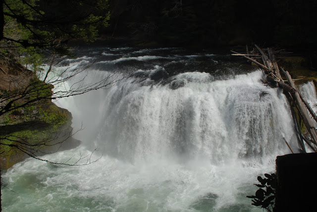
Lower Falls Lewis River


Dog Mountain, Washington
Dog Mountain


This popular hike is best done very early if you have to be weekend warriors. The hike is a workout straight out of the gate and you will finish exhausted! The views are wonderful once you reach the meadows near the top.


Indian paintbrush gave a preview of things to come as this area is famous for its June and July flower shows. Cleo is modeling her new doggie pack.


The ascent and descent afford glimpses of the views.


More of the Spring flowers casting a tantalizing reminder to retrace our steps in early Summer!