Silver Star via Ed's Trail
You really gotta want it to get here but wow what a view virtually the whole hike. This is not my first hike up Silver Star but I have always went up from Grouse Vista, an easy drive but way less scenic hike.
 Let's start with the drive....the last 10 miles of this drive are pretty treacherous on a dry day. That said, if you go slow and easy in a four wheel drive you will make it no problem. It is a popular approach, so if you go on a weekend, as we did just follow the others!
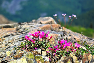
The hike begins with brushy switchbacks and beautiful vine maples. Then the wildflowers explode around you (in July). When you break into the open you gain views of Mt St Helens to the North and soon Mt Adams to the North-East. Eventually you merge with an old Jeep track. Ed's trail peels off about 20 yards along on the left. We took this trail and it wound its way up around the ridge giving great East and South-East views.
The trail winds up through wildflower choked open meadows surprising with a great postcard view of Mt Hood framed in the snow clad bowl below Silver Star and Little Baldy.
The trail rises up to the jagged rocks at the top of the spine then wraps around North.
Another surprise awaits in a spectacular natural arch, an arbor through which the trail runs. Traveling a bit further and past a sizeable cave, we were forced to turn back. The trail ascended a steep slope and was covered in snow. Our unpredictable pup would not make this a fun crossing. We decided to backtrack through the arch and take a small game trail up through the low huckleberry shrubs and join the Jeep track on the ridge.
Another surprise awaits in a spectacular natural arch, an arbor through which the trail runs. Traveling a bit further and past a sizeable cave, we were forced to turn back. The trail ascended a steep slope and was covered in snow. Our unpredictable pup would not make this a fun crossing. We decided to backtrack through the arch and take a small game trail up through the low huckleberry shrubs and join the Jeep track on the ridge.
 This is a real gradual climb through several deep snow patches to the summit of Silver Star. Here we were able to see Mt Ranier, Mt St Helens, Mt Adams, The Goat Rocks, Mt Hood and Mt Jefferson! What a place for lunch...
Our return trip we stayed with the Jeep trail down the entire ridge. We were surrounded by large jutting outcroppings of rock, flowers of all colors and deep green distant meadows begging to be explored.


